This glossary defines the fuel-related terms and classifications used throughout the platform to characterize the landscape and model fire behavior. Understanding fuel terminology is critical for interpreting simulation outputs, assessing risk across different vegetation types, and making informed decisions about suppression strategies and resource deployment. From fuel models that describe vegetation communities to fuel moisture values that indicate ignition potential and fire intensity, these definitions connect landscape characteristics to operational fire behavior predictions.
About Fuel Models
A fuel model is a set of standardized numerical inputs that represents a distinct vegetation type or fuel complex for use in fire behavior calculations. Fuel models are a primary input to the Rothermel surface fire spread equation and its derivatives, translating "what's on the ground" into the parameters a fire spread model can compute against.
Two fuel model sets are in wide use across wildfire agencies and platforms:
-
Anderson 13 (1982): The original 13 fuel models, developed by Hal Anderson at the USFS Northern Forest Fire Laboratory (NFFL) in Missoula, Montana, now the Missoula Fire Sciences Laboratory. Also referred to as the NFFL 13 fuel models. Grouped into four categories: grass, brush, timber, and slash.
-
Scott and Burgan 40 (2005): An expanded set of 40 fuel models, developed to address known limitations of the Anderson 13 set, particularly for grass-shrub mixtures and dynamic (live/dead ratio changing with curing) fuel types. Organized into seven groups: grass (GR), grass-shrub (GS), shrub (SH), timber-understory (TU), timber litter (TL), slash-blowdown (SB), and non-burnable (NB).
Scott and Burgan 40 is more commonly used operationally today.
Technosylva’s Fuel Models
Technosylva’s wildfire modeling is driven by detailed, high-resolution fuel data, which is one of the primary factors influencing fire behavior.
For a more detailed breakdown of the methodology behind Technosylva’s Fuel Models, please contact your Customer Success representative.
Core Modeling Approach
Technosylva's fire spread engine is built on the Rothermel (1972) surface fire propagation model, with Albini (1976) extensions, and supports both the Anderson 13 fuel model set and the Scott and Burgan 2005 forty fuel model set as inputs. Custom fuel models can also be defined for landscape characteristics that don't fit the standard classifications, most notably the expanded non-burnable and wildland-urban interface (WUI) classes Technosylva uses to support urban fire encroachment algorithms.
Sources
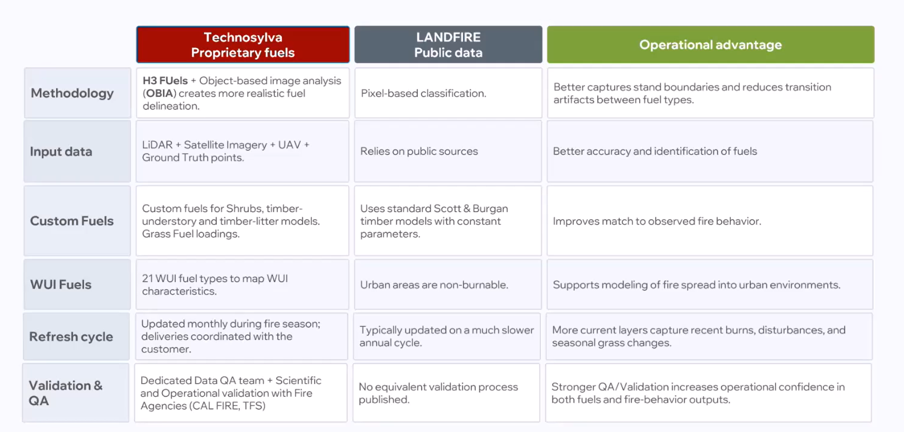
Rather than relying solely on public datasets like LANDFIRE, Technosylva develops and maintains its own proprietary surface and canopy fuels layers. Sources include:
-
H3 Fuels methodology and object-based image analysis (OBIA): an approach Technosylva positions as producing more realistic fuel delineation than the pixel-based classification used in LANDFIRE, particularly at fuel type boundaries.
-
Multi-source input data: LiDAR, satellite imagery, UAV imagery, and ground truth points, combined with standard sources like NAIP, Sentinel-2, and Landsat.
-
Custom fuel classes: Technosylva has developed its own shrub, timber-understory, and timber-litter model variants, along with dedicated WUI fuel types (21 as of Technosylva's public materials) to represent urban and WUI areas as burnable, since standard Scott and Burgan classifications and LANDFIRE both treat urban areas as non-burnable by default.
Updates
-
Fuels layers are updated regularly during fire season to capture burn scars, disturbance, and seasonal grass curing.
Fuel Models in Technosylva Products
Fuel models are a foundational input across Technosylva's product line, not a standalone output. They feed into fire spread simulation, risk forecasting, and consequence modeling wherever those products run.
Technosylva maintains multiple fuel-model layers for different analytical purposes: a current/start-season layer for present-day conditions, historical/no-scar layers for baseline comparison, and projected 2030 and 2035 Technosylva fuel layers for future-risk scenarios.
Planning (FireSight): Uses fuels data for longer-horizon risk assessment and mitigation planning rather than real-time simulation, supporting wildfire mitigation plan (WMP) development and asset hardening prioritization. Deliverables currently often use TSYL 2030 fuels, while 2035 fuels are used for longer-term future-condition scenarios or customer-specific analyses.
Validation
Validation of Technosylva’s fuel models is conducted through:
-
Internal QA process
-
Field validation and site visits
-
Scientific validation process comparing past fires to Technosylva simulations
Fuel Layers
Technosylva’s high-resolution input data includes multiple fuel layers, each contributing uniquely to fire behavior:
-
Canopy Fuels: Canopy fuel parameters that combine with surface fuel models to drive crown fire behavior.
-
Surface Fuels: A detailed table of individual fuel model codes and descriptions including Technosylva's WUI and land use classes.
Fuel Moisture Variables
Fuel moisture content plays a critical role in wildfire ignition and spread. When fuel moisture is high, fires are unlikely to ignite because much of the heat energy is used to evaporate water from the plant material before combustion can occur. Conversely, when fuel moisture is low, fires ignite easily and spread rapidly, as more heat energy is available for burning.
Technosylva models incorporate the following fuel moisture variables:
It is generally accepted that soil moisture content of 15% is the threshold for fire extinction; at or above this level, fire spread is unlikely.
Canadian Fuels Variables
Canadian customers may be accustomed to different Fuels terminology and variables. For Canadian fuel metric equivalents, please refer to the Canadian Glossary.
Fuels Management
Of the fire behavior triangle (topography, weather, and fuel), forest fuels are the single factor responsible for fire ignition and propagation that can directly be managed through prevention and assessment.
Technosylva products can support customers in prioritizing fuels treatments and quantifying risk reduction through territory-wide risk quantification to answer the following questions:
-
Which areas should I prioritize for the greatest reduction in risk?
-
Which treatment areas result in the greatest cost-benefit value?
-
Under what fire weather conditions do the treatments remain the most effective?
FireSim and Planning (FireSight) can be utilized on a project-by-project basis to quantify risk mitigation in a specific project, evaluating fuel changes across the landscape and climatology.
Suggested Trainings
You must log into Technosylva Campus to enroll in these trainings.
March 2026 Technosylva's Fuels Validation, Limitations, and Improvements Webinar