The Real-Time Positions page displays a live map of resource locations based on Automatic Vehicle Location (AVL) device data. Resources appear on the map when their assigned AVL device is active and transmitting a GPS position.
This is a view-only page. It does not require filters to load and has no data entry functions.
Map
The map displays administrative boundaries and resource position markers for your organization's geographic area. Use standard map mouse controls to zoom and pan.
Legend
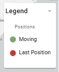
The Legend dropdown in the upper right corner shows the map symbols and what each represents. The legend is populated based on the resource types currently visible on the map.