The Print Map tool allows you to generate map products for an incident directly from Tactical Analyst (TA). Access it from the Print Map icon in the Main Toolbar.
Map Templates and Feature Standards
Templates vary by customer. Currently, international customers will see Basic and Operations templates.
Templates for US Customers
Each template follows National Wildfire Coordinating Group (NWCG) standards to determine which features appear on the final map.
Features included depend on the incident mode at the time of generation:
-
In Open mode, all features that meet the NWCG standard for that template will appear on the final map regardless of their status.
-
In Approval mode, only features that are both Approved status and meet the NWCG standard for that template will appear on the final map.
IAP Maps
The Incident Action Plan (IAP) map template includes the following NWCG standard features:
Points: Fire Origin, Water Source, Drop Point, Safety Zone, Unimproved Landing Area, Incident Command Post, Helispot, Division Break, Dip Site, Repeater, Restricted Water Source, Water Development or Draft Site, Zone Break, Branch Break, Water Tank.
Lines: Completed Plow Line, Completed Hand Line, Completed Mixed Construction Line, Fire Edge, Completed Dozer Line, Contained Line, Completed Fuel Break, Completed Road as Line.
OPS Maps
The Operations (OPS) map template includes the following NWCG standard features:
Points: Water Source, Drop Point, Staging Area, Safety Zone, Unimproved Landing Area, Incident Command Post, Helibase, Helispot, Mobile Weather Unit, Division Break, Dip Site, Repeater, Restricted Water Source, Water Development or Draft Site, Zone Break, Branch Break, Water Tank.
Lines: Completed Plow Line, Completed Hand Line, Completed Mixed Construction Line, Planned Hand Line, Planned Road as Line, Planned Plow Line, Access or Improved Road, Fire Edge, Completed Dozer Line, Planned Secondary Line, Planned Dozer Line, Contained Line, Completed Fuel Break, Planned Burnout, Planned Mixed Construction Line, Planned Fuel Break, Completed Road as Line.
Polygons: IR Intense Heat, Wildfire Daily Fire Perimeter, IR Heat Perimeter, IR Scattered Heat.
Briefing Maps
The Briefing map template includes the following NWCG standard features:
Points: Drop Point, Safety Zone, Incident Command Post, Helispot, Division Break, Dip Site, Zone Break, Branch Break.
Lines: Completed Plow Line, Completed Hand Line, Completed Mixed Construction Line, Fire Edge, Completed Dozer Line, Contained Line, Completed Fuel Break, Completed Road as Line.
Polygons: Wildfire Daily Fire Perimeter.
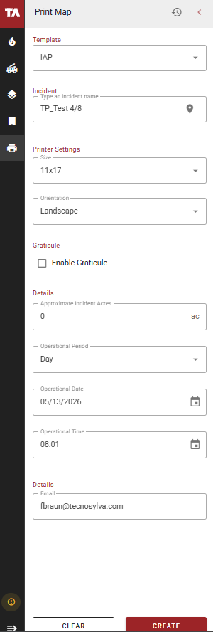
Create a Map Product
-
Open the Print Map tool from the Main Toolbar.
-
Select a template.
-
Search for and select the incident you want to create the map product for.
-
Select the Size and Orientation of the map.
-
Complete the Details section:
-
Approximate Incident Acres
-
Operational Period (Day or Night)
-
Operational Date
-
Operational Time
-
-
Select Create. A preview window will open showing the map canvas and a list of layers on the left side.
-
Adjust the map to the desired view and extent.
-
Toggle individual layers on or off using the checkbox next to each layer.
If the number of selected layers and their legend elements exceed the available space on the map, not all legend items will be visible on the final output.
-
Select Create to submit the map for generation.
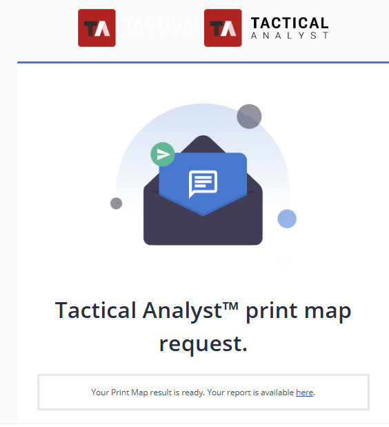
Map products are generated on the server and take several minutes to produce. You will receive an email when your map is ready to download.
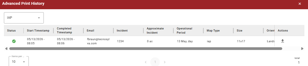
History Log
Select History in the upper right corner of the Print Map panel to view your previously generated maps. The history log shows the status, timestamp, incident details, and map details for each past map. Use the template type dropdown in the upper left to filter the log by template.
Select Download in the Actions column to download a completed map.